8 GPSMAP 4000 Series Owner’s Manual
Using Charts
USinG
ChartS
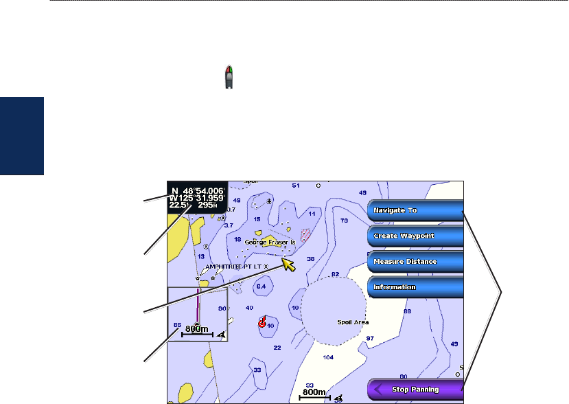
Panning the Navigation Chart
You can pan away from your current location and scroll to other areas on the Navigation chart. As
you pan past the edge of the current map display, the screen scrolls forward to provide continuous
map coverage. The position icon ( ) stays at your present location. If the position icon leaves the
map when you pan, a small window (inset map) appears on the left of the screen so that you can
keep track of your current position.
As you move the map pointer, the coordinate location of the pointer is displayed in the upper-left
corner of the map, along with the distance and bearing of the pointer from your current location.
Map
pointer
Inset
map
Pan
options
Pointer distance
and bearing
from current
location
Pointer
coordinates
1. Use the Rocker to pan the map.
2. Select Stop Panning to stop panning and return the screen to your boat’s current location.
Interacting With Objects on the Navigation Chart
As you pan the map, a list of options appear along the right side.
1. Move the cursor to a point on the Navigation chart.
2. Select an option. The options that appear are dynamic, and depend on the location of the pointer.
Select Review to view details of objects in vicinity of the cursor. (Review does not appear if
the pointer is not near an object; if the pointer is near only one object, the name of the object
appears.).
Select Navigate To to navigate to the selected location (page 7).
Select Create Waypoint to mark a waypoint at the cursor location (page 25).
Select Measure Distance to view the distance and bearing of the object from your current
location. The information is displayed in the upper-left corner of the screen. Select Set
Reference to measure from a location other than your current location.
Select Information to view tide (page 29), current (page 29), celestial (page 30), or local
services information near the cursor.
•
•
•
•
•


